UNDERSTANDING & USING TEMPERATURE CHARTS
Satellite-generated ocean temperature charts are an invaluable aid to the avid offshore sport fisherman who takes the time to understand how to use them. To an angler who can't tell the difference between fathom curve lines and thermal contouring lines, or who does not know the preferred water temperatures and habits of his quarry, the charts are of little interest. Ask a knowledgeable captain and he can probably tell you the water temperatures within a 20-mile radius of his vessel and how they correspond to bottom contour and the fish he is seeking.
Surface temperature charts tell you where you can locate potential fishing hot spots or what areas lack the dynamics to attract fish. They can indicate what species of gamefish would be more apt to be found in a specific location, so you can plan offshore fishing trips for the most productive type of fishing techniques- daytime trolling or nighttime chunking in the case of tuna. They can also indicate when you should save fuel, stay home and cut the grass. Not every chart generated through satellite imagery will provide earth shattering information, but it is exciting when you receive a chart that shows the water conditions and temperatures that point to a potential hot bite.
SATELLITE OCEAN TEMPERATURE CHARTS FOR SPORTFISHING
Offshore Satellite Services, Inc. was the first private company to offer ocean temperature fishing charts for locating bait and pelagic gamefish. We started developing the methodology for creating fishing charts from satellite data in 1984 offering crude low resolution charts. We advanced the science and our chart quality in 1988 with the development of our own custom chart software that is compatible with NOAA satellites, and have lead the field with continued advancements ever since. Other services have come into being since then, but none offer the resolution or detail available on Offshore Satellite Services charts, nor do they offer the in-depth evaluation and forecasting accuracy that can be obtained from our satellite imagery. When selecting a fishing activity forecasting service, keep these simple facts in mind.
If you are concerned about the health of our marine fisheries as much as we are, you'll be pleased to know that Offshore Satellite Services is the only company that does not offer its chart services to high-tech commercial fishing operations like purse seiners, longliners and pair trawlers. We will not be a party to the wanton over fishing these forms of high volume commercial fishing operations place on our public resources, our pelagic fisheries. Other services are as adamant about sending commercial vessels to potential hot spots as they are about sending you, the sport fisherman. It's an important mainstay for their businesses, not ours!
NOT ALL OCEAN TEMPERATURE CHARTS ARE CREATED EQUAL
Offshore Satellite Services' ocean temperature charts are generated daily from NOAA 12 and 14 satellites. We download our high resolution HRPT data directly from the satellites. This is accomplished using our new HRPT ground station and computer systems. We are the only company with our own HRPT system providing data to northeast fishermen. No other company servicing northeast fishermen can make this claim. Direct downloading of APT data is an inexpensive method of obtaining low grade satellite data. Going this route provides only low resolution (4.4- kilometer), unnavigated and uncalibrated data which is vastly inferior to HRPT data for precisely pinpointing areas of fishing activity. Offshore processes it own data, meaning we mathematically calibrate for temperature accuracy, and navigate the imagery for precise mapping accuracy. Our HRPT data is in our hands within 10 minutes of a satellite pass and we can generate highly accurate ocean temperature charts in our advanced computer systems using our own custom software immediately thereafter. The difference between Offshore Satellite Service's charts and those produced by other companies is startling! Let us explain more.
A 1-kilometer resolution infrared image contains 512 x 512 pixels, totaling 262,144 pixels. Using 1-kilometer resolution data, the satellite will average the water temperatures of each 1-square-kilometer pixel, providing one averaged temperature per pixel. This format provides the highest resolution, most accurate ocean temperature charting capabilities available.
The low resolution or ATP (automatic picture transmission) data used by other services is obtained by downloading information directly from U.S., Russian or Chinese satellites with an inexpensive antenna and home computer, which provides infrared ocean temperature information at 4.4-kilometer resolution. Low resolution imaging is less detailed because it provides data that averages temperatures for a much greater area. Every pixel on the image screen will be a batched and averaged area of far greater size, hence a far less detailed and less accurate accounting of what is actually there is found on low resolution charts.
If we zoom in on a 30 square mile area of the ocean's surface using 14-kilometer resolution data, the satellite would only supply 18 temperatures for the entire 30-square-mile region. The 1-kilometer data used by Offshore Satellite Services will accurately provide approximately 2,500 temperatures for the same area of ocean, so the tighter the resolution, the more detailed the temperatures contours on the chart and the more pronounced areas of rapid temperature change will be indicated.
WATCH OUT FOR THE SNAKE OIL SALESMEN
All satellite thermal images are developed from infrared sensing technology using onboard scanners. The scanners read the heat of the land and water and transfers these temperatures onto an image containing 255 shades of gray; each shade of gray representing a different surface temperature. Satellite scanners can not determine ocean water color, clarity, currents or current direction. They most definitely can not locate weed lines, bait, or fish, as some services would lead you to believe, so don't let them fool you with false claims or misleading promotional information!
An informed chart customer is Offshore's best customer because he understands the capabilities of this technology and he will not be easily mislead. At Offshore, we make every effort to educate our customers and take the mystery out of the science, so they can learn to interpret the charts themselves as they become more familiar with the capabilities of this technology. It also makes using ocean temperature charts more enjoyable and enlightening.
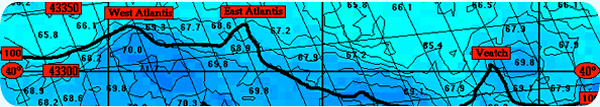
THERMAL CONTOURING
Offshore Satellite Services provides it's customers with ocean temperature charts that are thermally contoured at 1 degree Fahrenheit for regions and area enlargements. Our "Big Picture" charts will provide an angler with a "wide angle" view of a large area of ocean surface with 2-degree thermal contouring. This chart shows the major currents, and the eddies and fingers emanating from them, providing background information on how these features are affecting the entire area.
Service subscribers are also provided with regional charts and area enlargements developed with 1-degree thermal contouring that zoom in on the area within range of their home inlet or port. A contoured area showing a 70-degree temperature represents the surface temperature within that contour area accurate to within 1-degree Fahrenheit. Jump over a squiggly line into the next contour area and the surface water temperature will either increase or decrease as indicated on the chart.
What we are searching for with this technology are areas that contain thermal contouring lines that are very close together, representing an area of major or rapid temperature increases or decreases. A change of only two or three degrees can be all it takes to concentrate baitfish and, in many cases, locate the predator species you are fishing for. Both "Big Picture" and region or enlargement charts are provided complete with major bottom contours in fathoms and highly accurate LORAN grid overlays, so navigating to prime fishing areas is a snap.
WATER COLOR & CLARITY
As previously stated, water color and clarity can not be determined from a gray-shade, infrared thermal image provided by satellite. We do know that the Loop Current in the Gulf of Mexico and the Gulf Stream along the East Coast and El Niño and other major influencing currents along the West Coast can generate spin-offs, such as warm core eddies in the northeast, which contain clear, clean, deep-blue water. We also know that deep blue water does not readily mix with the surrounding waters. So, if we observe a filament or finger of warm water protruding from the Gulf Stream or loop current, or from a warm core eddy moving inshore, we can reasonably expect the warmer water to be bluer and cleaner than the inshore slope water found along the shelf areas.
Making assumptions of this nature are part of the process of interpreting the information on satellite ocean temperature charts. The more you use and apply these charts, the better you will become at interpreting the sometimes distinct and sometime subtle changes that can signal a potential fishing hot spot! Interpretation is part of the service you receive from Offshore Satellite Services, but the more experience you gain, the better you will become at making your own interpretations.
LOCATING POTENTIAL HOT SPOTS:
THE FOUR IMPORTANT VARIABLES
Bottom structure is an important component to successful fishing. Bottom structure often attracts baitfish and concentrations of baitfish attract gamefish. There are several common forms of productive structure. An underwater drop-off is the most obvious. Areas such as the 20-, 30-, 40-, 50- 100- and 500-fathom curves indicate underwater structure. The closer the bottom contour lines on a navigational chart, the more severe the drop-off and, usually, the better the area for attracting bait and gamefish. Areas of rapid bottom change often create upwellings of deep, nutrient rich colder water. When warmed, blooms of phytoplankton occur attracting baitfish and so on up the food chain.
The second form of structure, and just as important as bottom structure, is water color. Areas where water color changes rapidly over a short distance from green inshore water to deep blue will also attract and hold baitfish. The third form of structure and often the key element in creating and locating a feeding hot spot, is water temperature- specifically areas where rapid changes in water temperature occur. Color and temperature changes can form a "wall" as definable as one created by an underwater drop-off and should be heeded when searching for fish.
The final element in this picture is the presence of baitfish. Without bait, gamefish will probably not be abundant in an area and even if they are found, they will not stay there for long if baitfish do not come on the scene. Sometimes the first three variables are right, but because they are developing rapidly, baitfish have not been attracted to the area yet. Without baitfish, you are usually better off moving to another area rather than trying to wait out the arrival of fish.
With the advent of ocean temperature charts, today's modern fisherman can now combine all four variables to create a picture of fishing activity, saving fuel and wasted fishing time. Ocean temperature charts are used to determine potential areas of fishing activity prior to leaving the dock. Once on scene, the skipper's eyes determine water color changes and search for signs of life indicating the presence of baitfish and gamefish, his water temp gauge confirms areas of temperature change, his depthfinder pinpoints key bottom structure and can also confirm the presence of baitfish located too deep to be seen. Put them all together and you've got the makings for some hot fishing!
The key is to find these different forms of structure all in one location. An area containing a rapid water temperature and color change positioned above the 100-fathom curve or similar bottom feature, providing this area is holding baitfish, is definitely labeled a potential hot spot.
Always keep a watchful eye on the charts for warm water protruding from a major current or eddy. Warm eddies and filaments can provide two of the three different forms of structure. Also realize that it does not always require all three types of structure to concentrate baitfish. Often, just a major temperature and color break will act as a "block"to the movement of baitfish, carrying the bait schools along with its movements. Sometimes locating a strong temperature break is all that it takes to put yourself into a hot bite. When ocean surface temperatures in an area are bland, charts become less precise in pinpointing fishing activity.
OCEAN TEMPERATURE AND GAMEFISH
While gamefish have preferred water temperatures that they will tend to gravitate to, they are only "preferred" temperatures and not etched in stone. Knowing these preferred ranges will provide an angler with a better shot at locating the gamefish he seeks. Any gamefish can be caught outside its range of preferred temperatures, but hook-up ratios will drop the warmer or colder the water gets away from the preferred.
Keep in mind that charts indicate surface water temperature, but gamefish can frequent an area outside their preferred temperature by staying deep, frequenting the thermocline to maintain body temperature, only coming to the surface to feed briefly and then returning to the deeper water. This is common with some tunas and watching your depthfinder for fish marks on the thermocline can be an indicator of this condition. In general, bigger fish appear to be more comfortable in cooler water, while smaller fish of the same species will often tolerate water warmer than the preferred average because they generate less body heat to dissipate.
For several years, we have noticed that very large mako sharks are usually taken when the surface water is several degrees below the 65- to 68-degree preferred temperatures for this species. It appears that during their spring migrations, the larger fish swim ahead of the smaller makos, staying in the cooler water. Your chances of landing a truly large mako is therefore greater when if you concentrate your efforts away from the smaller fish and stay in cooler water or start your fishing earlier in the season.
For many years, we have monitored bigeye and yellowfin catches and correlated them with the surface temperatures that they were caught in. We found that the larger yellowfin and bigeye turns off when the water temperature reaches 74-degree range. A trolling bite will become erratic or stop altogether when surface temperatures get too hot, with these larger fish often staying on or below the thermocline only coming to the surface to feed ocassionally, and then only in quick bursts. Smaller yellowfin, in the 50- pound and under class, can be taken in temperatures as high as 77 degrees. As with makos, it appears evident that large tuna can be taken in water temperatures up to 74 degrees, but the chance of a hook-up in warmer water is much lower than in cooler water. Also, the chance of repeat hook-ups as you troll an area with relatively high water temperatures is greatly reduced.
Marlin prefer clean, clear, warm blue water. Monitoring major currents and eddies for spurs or filaments moving inshore is essential for locating a potential billfish hot spot. We have observed the marlin catch rate in the Northeastern canyons jump dramatically when a warm eddy begins a Westward movement toward inshore structure. Recently, the Southeastern canyon fishermen enjoyed a spectacular billfish season as a warm eddy remained for a long period atop their canyons.
The Gulf Stream, El Nino and other major ocean currents pump life into inshore fishing areas. Charting these potential hot spots in advance and having the ability to navigate directly to them not only saves hundreds of gallons of fuel during the course of a fishing season, but makes your fishing timemore productive and enjoyable and that is what it is all about!
Capt. Len Belcaro
Pres. Offshore Satellite Services